No live visibility
You find out after complaints.

SkyTrade gives municipalities real-time drone visibility, local rule enforcement, and a clear revenue model, built to work alongside existing federal airspace frameworks.
Built for municipalities, counties, state agencies, and major property portfolios.
A drone can cross a school, stadium, or hospital in seconds.
When residents complain, they call City Hall, not the drone company. They call you.
Most municipalities cannot:
You find out after complaints.
When incidents happen, there's no clean record.
Rules vary block by block, creating confusion.
Oversight stays a cost center. Each new flight is a new expense with no offsetting revenue.
Ungoverned airspace is risk.
Governed airspace is infrastructure.
Infrastructure creates value.
The Government OS for Low-Altitude Airspace
Atlas is the central hub where all airspace data, permits, enforcement, and monetization actions live. It connects to UTM, and operator command and control (C2) systems.
Formal authority, structured conditions, institutional records. Operators get authorized. Flights get logged. Drone work gets commissioned.
Civic illumination, not surveillance. Makes dark airspace visible. Identifies what is flying. Helps cities respond when it matters.
Detection alone is not security. Patrol drones launch on schedule or on alert. Live video verifies threats before ground teams respond.
The development rights above your land are a real estate asset. Inventory them, value them, and convert them into capital through sales, transfers, and development leases.
Our expert guides go beyond overviews - legally grounded analysis written for city attorneys, policy directors, and senior administrators who need defensible answers.
What authority cities actually hold, where federal preemption applies, and how to write ordinances that hold up in court.
FAA Part 107, Part 108 integration, and local enforcement obligations mapped to specific municipal requirements.
Monetization structures, fee authority, and case-law grounding for airspace governance programs that generate real revenue.
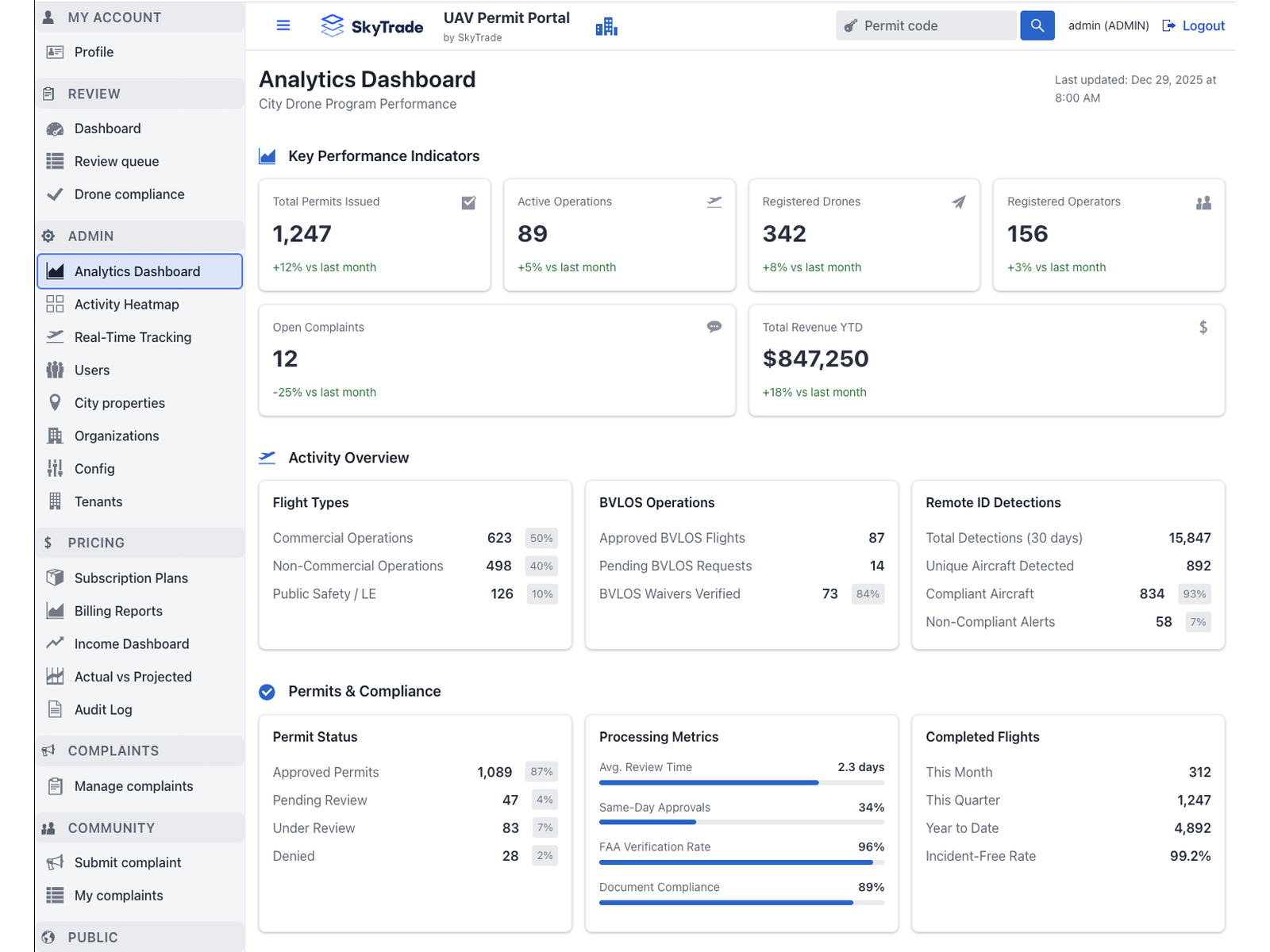
Permits issued, active operations, registered drones and operators, open complaints, and revenue, rolled up for the city manager, drilled down for the program lead.
Request a demo and we'll show how SkyTrade fits your local goals, your departments, and your rules. You'll see the dashboards, geofencing, real-time visibility, audit trails, and the revenue options that help fund safe operations.
Enterprise-grade security, built for government requirements, such as SOC 2 Type II compliant infrastructure with comprehensive audit capabilities.
Answers for procurement, legal, and operations.
No. SkyTrade does not replace FAA authority and is not a substitute for federal airspace regulation. The platform is designed to work alongside federal airspace programs and gives local governments visibility and governance tools for low-altitude airspace within their jurisdiction. Federal rules apply. SkyTrade helps cities operate effectively within that framework.
SkyTrade is designed to be revenue-positive for cities, not a budget line item.
Days, not months. SkyTrade is a cloud-based platform, so there's no complex IT project or hardware rollout required. Once an agreement is signed, your city can be operational within days. We handle configuration, onboarding, and training.
Not necessarily. SkyTrade works as a standalone software platform out of the box, using existing data feeds like Remote ID and LAANC. For cities that want enhanced capabilities, such as RF detection, optical confirmation cameras, or a drone as a first responder program, optional hardware modules can be added. The platform also integrates with systems your city may already have in place.
No. SkyTrade handles platform operations, monitoring, and maintenance. Your existing staff can use the dashboard for oversight, reporting, and decision-making, but you don't need to hire a dedicated team or assign someone full-time. We designed the platform so that a city manager or program lead can get what they need without technical expertise.
SkyTrade collects airspace activity data, including flight paths, operator registrations, permit records, and compliance events within your jurisdiction. The city retains ownership of its data. The platform is SOC 2 Type II compliant with 256-bit encryption, role-based access controls, 7-year data retention, and complete audit logs. Security documentation is available during the procurement process.
Yes. The platform is built to integrate with existing municipal infrastructure, whether that's a Drone as First Responder (DFR) program, GIS platforms, emergency response tools, zoning or public safety networks. Our team handles the integration work during onboarding.
That's how most cities start. You can launch with a single zone, neighborhood, or use case (like drone permissions in an area of natural beauty) and expand as you see results. Our onboarding is designed to be low risk, with real data from day one.
SkyTrade includes a complaint-tracking module that logs resident reports and correlates them with flight data. Instead of fielding complaints with no actionable information, your team can see exactly what was flying, when, and whether it was authorized, and respond with specifics.
No. The platform serves municipalities, counties, and state agencies of all sizes, as well as major property portfolios. Whether you're a town of 5,000 or a county of 3 million, the platform scales to your jurisdiction. Smaller municipalities often benefit the most because they lack the resources to build drone oversight programs from scratch.
At the end of the pilot, you'll have real operational data, flight data, permits issued, revenue generated, and compliance enforced. You and your team review the results and decide whether to continue. There's no obligation. If you move forward, we transition to the full pricing model, which is structured so the platform pays for itself through flight fees and airspace revenue.
Absolutely. We regularly brief elected officials, city councils, county commissioners, and policy teams on the state of low-altitude airspace, what's coming with commercial drone operations, and how jurisdictions can get ahead of it. Whether you need a formal presentation for a council session, a working session with your policy team, or an introductory briefing for stakeholders who are still getting up to speed on the issue, we're happy to present, answer questions, and tailor the conversation to your jurisdiction's specific concerns and priorities. Request a demo and let us know who needs to be in the room.
The benefits extend well beyond the municipal offices. For residents, SkyTrade means fewer unknown drones over their homes, schools, and parks. When they do file a complaint, the city can actually respond with specifics. For the jurisdiction as a whole, the platform creates a new revenue stream that flows directly into city budgets, funding public safety, infrastructure, or community programs without raising taxes. It also means safer skies: authorized operators who avoid sensitive areas, enforce no-fly zones around hospitals and stadiums, and are held accountable for their actions. In short, residents get safer neighborhoods, the city gets funded oversight, and commercial operators get clear rules. Everyone benefits from governed airspace.
Three forces are converging that make this urgent.
First, the money is already in the air. Commercial drone operations (deliveries, inspections, surveying, agriculture) are growing rapidly, and operators are flying over your jurisdiction today. Without a governance layer, that economic activity generates zero revenue for your city. SkyTrade turns unmanaged airspace into monetizable infrastructure, creating a new revenue stream from the flights already happening overhead.
Second, safety and security can't wait. Drones can carry cameras, payloads, and sensors over schools, hospitals, stadiums, government buildings, and private property. Without visibility into what's flying and who's operating, cities have no way to protect residents, enforce local ordinances, or respond to incidents. Every day without oversight is a day your jurisdiction is exposed.
Third, the federal government is pushing for action. Initiatives around Remote ID and counter-UAS are accelerating because the national security implications are real. Protecting Americans from bad actors using drones to infringe on privacy, trespass, smuggling, or disruption is a priority. Cities that build local governance infrastructure now will be aligned with federal policy. SkyTrade puts your jurisdiction ahead of the curve, with the tools, data, and revenue model already in place.